Update from base camp (Cliff Notes)

I have been at base camp for six days now. All is good, other than the internet access which is highly sporadic and way worse than last year. My inability to communicate semi- regularly with my family has been frustrating.

I spent a good chunk of the past several days writing a detailed blog post, in which I described our trek up to base camp, the individual members of my climbing team, our approach to climbing the mountain this year, and details of what we have been up to recently. I hoped to post it today, but – when I woke up this morning- I found it had vaporized overnight. Gone, and not recoverable. I felt like someone kicked me in various body regions, and I have spent the past several hours getting over my disappointment and frustration.

My conclusion was to resort to “Blog Post Plan B”, a quick and dirty Cliff notes version of what I wrote about in detail. Then to hope I can send it out today before it too vaporizes. So here you go:

  • We did the two day trek from Dingboche to base camp in one long day, to avoid exposure to Covid and other potential bugs in crowded tea houses along the way. It was wonderful. I savored every step.
  • I have been pleasantly surprised by how great it feels to be back here; both trekking through the Khumbu valley and returning to base camp. Base camp is a beautiful place and holds strong memories.
  • I am climbing this year with Expedition Leader Phil Crampton and his “Altitude Junkies” team. Phil is legendary in mountaineering circles and has a unique approach to his expeditions, which are small teams of experienced climbers. He expects you to show up prepared and self sufficient. He also has a wonderfully irreverent sense of humor, is as non-commercial as you could find, and actively avoids publicity and social media.
  • The vibe is one of climbing a mountain with close friends. The banter around the dining tent is relaxed and congenial. We share in all aspects of expedition planning, and Phil encourages us to personalize our approach to climbing the mountain. I am loving every bit of it.
  • That all said, Phil is ruthlessly organized and the clear leader, with painstaking focus on the details that matter.
  • Our team is small and highly experienced. Two other climbers in addition to me: Teemu – a 40 year old Finnish backcountry guide, and Robert- a 60 year old American who has climbed all over the world, summited Everest in 2016, and was the first American to ski off the summit of Manaslu (8th highest mountain in the world ). Plus Phil, plus Sirdar Pasang Ongchu, plus an outstanding Sherpa team who have been with Phil for years.
  • I REALLY like the team and our overall approach
  • We will head into the icefall tomorrow at midnight to start our first rotation up the mountain. Will climb to some combination of Camps 2 and 3, then return to base camp around May 3.
  • Then we will wait for a weather window and go for the summit. In contrast to most teams and to what our team did last year, we will not do a second acclimatization rotation before launching our summit push. Our “two rotation model” instead of three rotations is a big piece of what I wanted to do differently this year. It means less trips through the dangerous icefall and less wear and tear on body and mind before launching the summit bid. Offsetting this is less time spent acclimatizing. You have to believe you are strong and do well at high altitude. Based on my experience last year, I think I can handle it. Also, the week I spent on the Makalu trek between 18,000-20,000 feet should help. Time will tell.
  • So far, I am healthy (a big deal on Everest climbs) and feeling strong. But things can change quickly. I will know a lot more after we complete our first rotation
  • A few days ago we had our “puja” ceremony, organized by our Sherpa team, in which a lama seeks blessing from the mountain gods to climb the mountain and for safe passage. It turned out the lama who walked three days up the valley to conduct the puja was the same one who blessed our team last year at Pangboche monastery. For some reason, encountering him again, a year later in this remote context, moved me. At the end of the puja he tied around the neck of each team member a small red cord with a hand woven amulet, to keep us safe on the mountain. I hope to wear mine to the summit, and won’t remove it until I am down safely.
  • The number of climbers on Everest is down this year. 300 permits issued versus over 400 last year. At least 50 climbers can be expected to head home for various reasons before the summit pushes begin, so it is reasonable to expect around 250 climbers (plus Sherpa support) to be trying for the summit during the month of May. This is a pretty manageable number, especially if the weather cooperates and serves up multiple “weather windows “: days the jet stream moves off the summit so it can be approached.
  • Base camp is a special place. Cold nights, clear mornings, avalanches crashing down from surrounding peaks at all hours, glacier on which our tents are pitched creaking and groaning, amazing stars at night. I zip open my tent each morning and have a hard time believing I am here (again).
  • Internet willing, I will post an update, in some fashion or other, when we get down from our rotation. Meanwhile, banging this out just now has helped me get over my bad mood this morning when I discovered my detailed post had been lost.
  • Continued thanks to all for your interest and support. It means a ton!

Photo of our portion of base camp. Yellow dining tents. Blue personal sleeping tents. Pumori and Lingtren on other side of valley from Everest/Lhotse/Nuptse:

Photo from my tent door; Everest west shoulder and lower Khumbu icefall:

Photo of the lama placing the protection cord and amulet around the neck of one of our climbing Sherpas:

Photo that I posted last year of our route. (I share this courtesy of Alan Arnette, the premier “live” chronicler of climbing on Everest. Those of you who are really into this stuff should check out the “Everest 2022 Coverage” portion of Alan’s blog, in which he posts frequent updates and commentary on what is happening on the mountain):

From Dingboche


As described in my last post from Kathmandu, I decided to replace the traditional approach to Everest base camp this year with a longer, more challenging trek/climb through the remote Makalu-Barun region. I sought to add a new life experience into the mix as I return for a second attempt on the mountain.

Yesterday, my friend Bob and I pulled into the Khumbu village of Dingboche after eighteen days of hard trekking and climbing. For the first half, we were joined by Bob’s wife Ann and friend Brad. We experienced stunning natural beauty, trails and villages devoid of foreigners, comradeship, physical challenge, and high pass crossings that tested our limits. If I headed home tomorrow, I would count this among the cherished experiences of my life. Mission accomplished.

THE FIRST HALF

As is often the case, getting from Kathmandu to the start of our trek was a challenge in its own right. Our plan was to fly to the village of Tumlingtar, then ride in a jeep five hours to the smaller village of Num, where the road ends. Unfortunately, cloudy weather had grounded the flights for days. We showed up at Kathmandu airport in any event, hoping for the best. After waiting in the chaotic domestic departures area for several hours, we were told that that Tumlingtar airport had just opened. The small plane boarded. We were elated.

We took off and flew along the edge of the mountains, with great views of the highest peaks rising above the clouds. As we approached Tumlingtar, the plane suddenly did a 180 degree turn. The high peaks that had been visible on the left side of the plane were now on the right side of the plane. The pilot announced that Tumlingtar airport had again closed and we were returning to Kathmandu, which we did.

The weather forecast for the following days looked no better, so we hastily diverted to Plan B: finding a helicopter that could take us directly to Num. The next day we were back at the airport. While conditions remained very cloudy, the helicopter operators thought they could follow river valleys and navigate safely. As we handed over our bags, another problem arose. Our collective luggage was 70 kilos over the takeoff limit. The operators wouldn’t budge, and we needed every item in our luggage for the trek.

After an hour of negotiation, a solution emerged. Seventy kilos of helicopter fuel were identified in Num, connected to a local dam construction project. This would be provided to the pilot in Num for his return flight to Kathmandu. Seventy kilos of fuel were then offloaded from our reserves leaving Kathmandu. After several more hours of waiting, we boarded the helicopter and took off.

Heavy clouds prevented the pilot from flying the direct route over the ridge lines. As planned, he stayed low and used river valleys to navigate. For a long while, we followed the Sun Kosi, one of Nepal’s renowned rivers which I kayaked with three great people in 1982. It was a thrill to look down and pick out specific rapids we negotiated. I thought I could also identify specific river banks where we camped, but that was probably stretching it.

Near Tumlingtar, the pilot swung hard left and began following the Arun river up into the foothills. A while later, he swung right and followed a steep ridge up into the clouds to where Num was perched. We circled and landed in a small enclosure between houses, with much of the village looking on. We had made it!

Our trek staff had been in Num for several days, waiting for us. In the more popular trekking areas, employing large retinues of support staff as was done by expeditions historically has been replaced by traveling lighter, relying on small lodges called “tea houses” for lodging and meals. Given the limited tea house infrastructure in the Makalu region, coupled with my desire to eat well and stay healthy in advance of Everest, we were in full “expedition mode”. In addition to lead guide Pasang Gombu Sherpa and assistant guide “Bali” Tamang Sherpa, our retinue included a cook, three cook staff, and thirteen porters. The number of porters would be reduced as the trek advanced.

Given the technical nature of the climbing that Bob and I would encounter in the back half of the trek, I had worked hard to secure experienced guides. Pasang Gombu and Bali had eleven Everest summits between them and were very familiar with our route. Both were on Everest last year, climbing with a group on a similar schedule to ours. They too had been forced by the bad weather to turn around. We had lots of notes to compare.

Given that it was mid afternoon when we arrived in Num, Gombu and Bali assumed that we would spend the night there and start our trek the following morning. But we were eager not to lose another day and convinced them to hit the trail right away, even if it meant arriving at our destination after dark. So that is what we did; descending 3,000 vertical feet through steeply terraced fields, crossing the Arun river on a suspension bridge. and ascending 3,000 vertical feet up the other side of the valley to the village of Seduwa. We hiked the last hour in darkness, and shortly before Seduwa it began pouring rain, but we made it. Our trek was officially underway. It felt great.

Over the next few days, we settled into our trekking rhythm, passing through small villages, laboriously cultivated fields, and rhododendron forests. It was the charm I have long savored when trekking in Nepal, enhanced by being in a region that sees few foreign visitors. It was timeless. Here is the view out of my tea house window on night two:

As we ascended, we left the year-round villages behind and temperatures dropped. On day four we crossed the 13,500 foot “Shipton Pass”, named for the British climber who passed through this area in 1952 with Edmund Hillary as part of the Everest reconnaissance expedition. The heavy rains we had experienced lower down caused the pass to be covered in snow:

By day seven we were among the high peaks:

On day eight we arrived at Makalu base camp, beneath the world’s fifth highest mountain. The next day, we started before dawn and climbed to a saddle at 17,000 feet, where we had spectacular views in all directions, including of Everest glowing in the early morning light. Here is a photo of Pasang Gombu and our group, with Makalu behind us:

The following morning, a helicopter arrived to, in the words of our logistics coordinator, “extract” Ann and Brad to Kathmandu for their return flights to the US. The first half of the trek was over. I had loved every minute of it. The landscape had been spectacular. I had enjoyed feeling a bit like Shipton and other early explorers, the only foreigners passing through remote valleys, far from contemporary infrastructure, (well, other than the helicopter). I also loved approaching Everest on foot from afar; the views of it growing more intimate with every passing day, my climbing route up the southeast ridge coming into ever clearer focus.

I also knew that the tenor of the trek would now shift. I looked forward to that as well.

THE SECOND HALF

For the back half of the trek, Bob and I would leave rudimentary tea houses behind and sleep in tents. We would spend over a week above 16,000 feet, crossing three 20,000 foot passes that required technical climbing skills. We would traverse a vast realm of rocky moraines and glaciers; the two of us and our support team the only people within hundreds of square miles.

As we climbed above Makalu base camp, the terrain immediately grew more rugged. Here is a photo of our porters ascending a rock strewn slope with Everest and Lhotse looming in front of them. Everest is the one on the right. It looks smaller because it is further away:

And here is one of our tents at night, with Makalu bathed in moonlight:

On day fourteen, we crossed the first of the three passes, Sherpani Col. Here is a photo of the climb up to the top. Once there, we rappelled several hundred feet down the other side and camped on a large glacier:

The following day, we crossed the glacier, climbed to the top of the second pass, and prepared for a challenging descent involving long rappels and some tricky traverses. It was here that near-disaster struck.

While descending, Bali was hit in the head by a falling rock and seriously injured. With a massive open wound bleeding profusely, and the nearest village a several day walk away on the other side of high passes, he needed to be evacuated. To make matters worse, the satellite phone that Gombu carried was dead.

Those of you who recall my January 2022 post “The Fine Line”, will appreciate the happy irony of what happened next. Sitting on a narrow ledge at the top of the pass, I was able to use my Garmin satellite tracking device to contact our logistics people in Kathmandu and initiate a rescue. A couple of hours later, a helicopter whirred overhead and circled the glacier until it located Bali. It took him to the hospital in Kathmandu, where he remains as I write this. Fortunately, the prognosis is for full recovery.

Meanwhile, our team was scattered; some already at the bottom of the pass, and others still at the top. Bob and I eventually rappelled down and began the long descent through the glacial moraine to our next camp. Pasang Gombu, now minus an assistant guide, heroically coordinated the descent of the remaining porters and gear. Aided by the light of a full moon, they arrived at camp late that night. It was a long day for all involved, but all’s well that ends well.

Day seventeen found us crossing the final pass, Amphu Lapcha, which also turned out to be the most challenging. We climbed up steep ledges of rock and ice to a narrow cleft in the ridge, then rappelled down the other side with a thousand feet of air between us and the glacier below. Pasang Gombu, still short handed, displayed amazing patience and strength in setting up the belays. Here is a photo of Bob descending the back side of Amphu Lapcha:

When we reached the bottom of Amphu Lapcha, we had officially arrived in the Khumbu region. We followed a trail down toward the main valley and camped a short ways above the village of Chhukhung. Then, yesterday, we continued down to Dingboche. As we approached, we began to encounter groups of trekkers and climbers, something we hadn’t seen since leaving Num. Arriving in Dingboche, where Jill and I stayed in 1990 and I stayed last year en route to Everest, felt like a homecoming. The dots of this year’s approach trek had been connected.

REFLECTING AND SHIFTING GEARS

The trek was all I hoped for, and also contained some surprises. As mentioned previously, the feeling of moving on foot through remote, timeless valleys was very powerful. So too was the actuality of climbing over high, desolate passes to move from one major mountain region to another. Doing this in the company of friends was really gratifying.

On the surprise side, the physical and technical challenges involved in crossing the high passes were greater than anticipated. Bali’s injury weighs heavily on my mind, and the outcome was close to being much worse.

On another dimension, I found myself “homesick” at times, in a way I haven’t experienced on other recent climbs. I found myself thinking often about Jill, John, Holly, Will, and the rest of my family; wondering what they were up to and craving news. I am guessing part of this was caused by the sheer remoteness of the Makalu region. Also perhaps that this is my second year in a row of doing this. Now back in the Khumbu, I can access the internet sporadically and exchange occasional emails and texts. It feels great.

The majority of our trek staff disbanded yesterday and headed down the Khumbu valley, to their villages or in search of additional work. Bob and Pasang Gombu departed on the final two day walk to Lukla, from where Bob will fly back to Kathmandu and on to the US. I will rest here for a couple of days, meet my climbing team, and then head up the valley on the two day walk to Everest base camp. We should arrive there on April 22.

Here is a photo of Pasang Gombu and me, taken just before Bob and Gombu left Dingboche. The window on the right is my tea house room from where I am writing this blog post. The scarf around my neck is the ceremonial “kata”, presented by Gombu both as a celebration of our successful trek and also as a blessing for Everest:

While I am intensely grateful for the past three weeks, my mind is now shifting toward Everest. I need to be 100% dialed in, both physically and mentally. I think I am, and look forward to the weeks ahead.

My next post will be from base camp. I will describe our climbing team, our approach to the mountain, and the overall scene on Everest this year.

As always, heartfelt thanks for your interest and support!

Back in Kathmandu

A couple of nights ago, Jill dropped me at Logan airport and I repeated the same journey I made a year ago: Qatar Airways to Doha, an eight hour layover in one of the nicest airport lounges on the planet, then another Qatar flight to Kathmandu. There was a great view of the Annapurna range out the window shortly before landing.

View of Annapurna from seat 3A


When I arrived in Kathmandu last year, my frame of reference compared it to a place I had experienced in the early 1980’s and 90’s, when I soaked up the Shangri-La vibe and used it as a base for outdoor adventures that became cherished life memories.

My return this year feels different. My frame of reference is strongly linked to last year, when I arrived in Kathmandu eagerly preparing to climb Everest, and then returned after almost two months, replaying in my mind an aborted summit attempt and a challenging descent through a blizzard. The post climb week I spent quarantined at the Yak and Yeti hotel, with the city in full Covid lockdown, was intense and full of reflection; one of those intersections of time and place that stay with you for a long while.

So when I arrived yesterday at Kathmandu’s Tribhuvan airport, I wasn’t thinking about how it looked when I first landed here in 1982. Then, I stood outside a small customs building on a grass-lined runway, savoring the mountain air and the sunlight filtering through the trees. Instead, as we left the crowded, sprawling airport yesterday and drove through chaotic streets full of cars and motorcycles, I was thinking back to last year’s arrival. We drove the exact same route to the hotel. The sights out the window were the same. It had the feeling of ritual. As I re-entered the Yak and Yeti, I felt like I was being teleported back twelve months to that same intense intersection of time and place.

It is good to be back. I continue to mourn the population growth, vehicular traffic, and air pollution that have turned what used to be an exotic valley town into a crowded Asian city. But Kathmandu remains a fascinating place, and the Nepali people remain astoundingly friendly and polite. I am also excited about what I am here to do, which includes more than just repeating last year’s climb.

A different approach

I am climbing Everest with a different team this year, and will explain more about that in a future post. I am also approaching base camp by a different route, accompanied by good friends Bob Burnham, Ann Burnham, and Brad Brown. Here is a photo of Bob, Ann, and I upon arrival at Kathmandu airport:

3/4 of the trek team

Brad had arrived a couple of days ahead of us. Here is photo of him taking the town by storm:

1/4 of the trek team
photo credit: Brad Brown

Our trek will take us through the relatively remote territory east of Everest to the base of Makalu, the fifth highest mountain in the world. Brad and Ann will then helicopter back to Kathmandu and fly home. Bob and I will continue over a series of high passes and drop down into the Everest region. The remoteness of the area requires us to be self sufficient, with porters assisting in carrying all the supplies and gear necessary for the three week journey. The high passes will involve some technical climbing at altitudes around 20,000 feet, as well as extended glacier travel. We will be supported by experienced Sherpa guides.

Here is a photo from Google Earth that provides an overview. The red line shows the standard trek route from Lukla to Everest base camp, through the heart of the Solu-Khumbu region. This is the approach I did last year, and the approach the rest of my Everest team will do this year. The blue line shows the route Bob, Ann, Brad, and I will follow through the Makalu-Barun region, starting from the village of Num in the lower right corner. (Num is not labeled. It is at the top of the squiggly yellow line, which is a dirt road built recently to facilitate construction of a dam on the Arun river.) Makalu base camp, where Ann and Brad will depart the trek, is located on a glacier near the “M” in Makalu. The village of Dingboche, where Bob and I will conclude our traverse of the high passes, is in the upper left, where the blue and red lines connect. I will meet my Everest team here, and then head north on the red line to Everest base camp. Bob will head south on the red line to Lukla, from where he will fly back to Kathmandu.

The path less travelled to Everest Base Camp


As mentioned in a previous post, the “Makalu Three Passes” trek has intrigued me since hearing about it over thirty years ago. When I decided to return to Everest, I liked the idea of injecting a new element of life experience into the equation. The area is far removed from the trekking mainstream, the terrain will be stunning, and the idea of climbing over high passes from one mountain region to another excites me. It will also be great to share the experience with friends. At the same time, I need to be mindful and conserve energy. It will be important to arrive at Everest base camp with mental and physical batteries fully charged.

The past day and a half have been filled with tactical details: obtaining stacks of rupee notes to pay the porters, submitting paperwork for permits, doing a final gear check, and handing off a large duffel of equipment that will be sent directly to Everest base camp to await my arrival. I am leaving a small duffel here at the hotel, with clean clothes and other items, for my return in a couple of months. As I packed it, I was thinking about how much will play out between now and then, and how many hopes and dreams are in the mix.

We fly tomorrow morning to a town named Tumlingtar, in the lowlands south of the Makalu region. From there we will hop in a jeep for a bumpy five hour ride up to Num, spend the night, and then start walking. The flights are notorious for weather-related issues, and the one to Tumlingtar was cancelled yesterday and today. We are hoping for better luck tomorrow, but will get there one way or the other.

In contrast to the Everest region, internet service in the Makalu-Barun is essentially non existent. The next time I post something will likely be from Dingboche, which Bob and I should reach around April 20. I should have lots to report.

Thanks for following along!

Dialing it in

The winter has flown by. I leave for Nepal in a week. Time is accelerating and the days are filled with endless pre-departure details. Things like final gear purchases, reviewing packing lists, doctors and dentist appointments, and tying off responsibilities so I can spend two months off the grid. I am also in the final stages of my training, pounding out the last leg burning hill climbs and strength workouts, while lightening the overall volume to assure I get on the plane rested and ready to go.

Our final weeks in Vermont were great. Jill and I moved from a rental house in Stowe, where we spent the first half of the winter, to another in Greensboro, where we enjoyed interacting with the rugged Northeast Kingdom landscape, interesting people, and a vast cross country trail network. I headed out for multiple hour skis; crossing fields, ridges, and valleys; marveling at how much terrain I could cover between villages. There were endless kilometers of trails that looked like this:

Greensboro Trails: February 2022
Photo credit: Jill French

I also continued to put in at least one solid hike a week, carrying a pack weighted with water jugs. As I have done each of the last few years, one of them was up Mt Washington, where a winter ascent provides a big mountain experience unique to New England. When you get above tree line on Washington, you are truly in the realm of the mountain gods. Here is a photo of my friend Graham, half way to the summit on a perfect bluebird day:

Mount Washington: March 2022

And here is a photo of where I am soon headed, taken last spring on one of our acclimatization hikes. This view thrilled me when I first saw it thirty years ago, it thrilled me last year, and it will thrill me again in a few weeks:

Everest and Lhotse: April 2021


Past readers will recognize many of the features in the photo: the base camp tents at the bottom, the Khumbu icefall in the middle, the Lhotse face in the upper right, and Everest’s summit in the upper left. Last spring, we got to Camp 4 at the South Col, in the notch at the top middle, before the second major cyclone to hit the mountain in a month forced us to turn around and descend the Lhotse face in a blizzard.

Here is a photo I encountered recently of that cyclone as it made landfall on the Indian subcontinent, while we lay in our tents high on Everest hoping to climb to the summit before the storm hit.

Cyclone Yaas


This photo reminds me of how much our fate last year was determined by the weather gods, and how much I hope they smile on us this year.

Mountaineers talk frequently about having their gear “dialed in”, by which they mean that they have fine-tuned every detail and are calmly and confidently ready to put it to use. For me, this concept applies beyond gear. The months and weeks leading up to an expedition are a continual process of optimizing the tactical, physical, and mental factors that will be required for success. I am happy to report that I am feeling dialed in.

On the tactical dimension, I like what I know about the small, experienced group I will be climbing with. I have methodically planned my approach to the mountain, including how I will acclimatize, where I will use bottled oxygen, and what kind of Sherpa support I will engage. While my gear is largely the same as last year, I have made some small adjustments. As shared previously, I felt really good about our approach and team last year. The only thing that didn’t go as hoped was the weather, over which we had no control. The changes I have made this year reflect a combination of fine tuning and “mixing it up” on a few dimensions. I will describe these changes in detail in a future post.

On the physical dimension, I am right where I want to be. Again, I was really pleased with how my body performed last year, but a few adjustments to my training program have me feeling even more ready this year. Those of you with endurance sport experience are familiar with the stage I am at now. After ten months of heavy base training, on top of three years of prior preparation, “the hay is in the barn” and it is time to taper toward a peak. As I lighten up the overall training volume, interspersed with a few high intensity sessions, my body is starting to feel rested and turbo charged. It is a great feeling, and an even greater feeling at age 62, where holding one’s own against the passage of time is a challenge. I was reflecting today that, depending on the choices I make after I return from Everest in June, I may never again be at this level of fitness. It was a simultaneously gratifying and wistful realization.

I am also feeling good on the mental dimension. First and foremost, I am glad I am returning to Everest. The passage of time brings clarity to decisions, and this one is feeling right. Family and friends continue to be wonderfully supportive. This means the world. It is also striking how beneficial having experienced something previously can be. I picture clearly what I am heading into. This streamlines the mental energy involved. I know where I am going, I know why I am going, and I know what I need to do when I get there. I am dialed in.

Yet there are still moments when I wake up in the middle of the night and realize I am thinking about the mountain. Sometimes it is about mundane logistical details, but more often it is about moments up high, where you are pushing your physical limits to the edge in a foreign and hostile environment. A former astronaut who climbed Everest some years ago described his summit night as the closest thing to a space walk that he would ever experience on earth. Space walks can be both exhilarating and challenging. While this climb is a gift and a life long dream, there are occasional feelings of dread in the mix.

One thing that will be different this year, involving no feelings of dread, is my approach to base camp. As described in a previous post, three friends will join me in trekking through the remote valleys east of Everest to the base of Makalu, the fifth highest mountain in the world. Two of us will then climb over three 20,000 foot passes and drop down into the Khumbu Valley near Everest, where I will meet my climbing team en route to base camp. This trek will be an adventure in its own right and I am really looking forward to it. Stay tuned for details.

I will start posting more frequently as things unfold in Nepal. For those of you who followed my climb last year, I will focus on what is different this year. For those of you new to this blog, who when streaming a second season on Netflix find past highlights helpful, a quick scan of the archives from last spring will provide relevant context.

Last year at this time, just before leaving for Nepal, I did a final traverse of the Presidential Range with son Will, including Mount Washington. Reflecting on it afterward, I wrote: “This day was all that I cherish in the mountains: exhilarating beauty, physical challenge, spiritual connection with nature, and the reward of shared experience……All of the Everest prep I have been doing would have been worth it if the only thing it did was get me in shape for (this)”. Here is a photo of me on Mt Washington recently. I was feeling exactly the same way.

Photo credit: Graham Schelter


I fly to Kathmandu on March 27. Lots to look forward to!


The fine line

Jill and I have been renting a farmhouse in Vermont this winter. It is a lovely spot and a perfect base for my Everest preparation. Here is a photo taken in early January, as the snow level was just starting to build.

Winter 2022 base camp


I have been training hard, with a daily mix of strength workouts, long cross country skis, early morning skins up Mount Mansfield, and long winter hikes with a heavy pack. At this time of year, clear days like the one in the photo are typically accompanied by arctic cold. If you dress appropriately and keep moving, it is exhilarating to be outdoors.

Most of my training is done alone and I enjoy it. There is something spiritually meditative about moving through crystalline winter landscapes, in the company of my thoughts, maintaining a steady pace over long distances. There is also the satisfaction of feeling my body getting stronger each day, building the reserves it will draw on this spring to endure punishing days at extreme altitude.

Among my current activities, the solo winter hiking has some unique dynamics. Rock ledges that are enjoyable scrambles in summer can become serious challenges when covered in ice. Snow covered trails can be hard to follow. Straightforward ridge walks above tree line can become come life threatening when whiteouts suddenly reduce visibility to zero. The combination of sub zero temperatures and strong winds can, in minutes, turn a strong hiker into someone unable to care for themself. Cell service is often non existent. If a solo hiker slips and, for example, sprains an ankle with no one to call for help, what started out as a routine New England hike can become a serious situation.

Managing this fine line is a core element of winter hiking’s challenge and satisfaction. It has much in common with solo sailing; where every move needs to be carefully planned and executed. The details matter. Important conversations are conducted silently in the head of the practitioner. At a surface level, the hiking and sailing are routine and easily taken for granted, but the fine line lurks and commands respect.

I enjoy managing this fine line and don’t lose sleep over it. But I do take it seriously, especially when climbing the taller New England peaks alone in winter. I carefully check weather forecasts, fill my pack with backup items that are unlikely to be needed but would be critical in an emergency, and make sure someone knows my intended route and expected timing. Then I go out and rejoice in having the mountains largely to myself, confident that I have my downside covered.

This winter I have been climbing on average one large, (by New England standards), mountain a week . Targeting clear weather, I have been out often in sub zero temperatures. As long as I keep moving, take breaks at the right places, and wear the right layers, it works out great. My chosen climb this week was an extended loop over Camel’s Hump, the third highest mountain in Vermont. Careful study of the weather forecasts helped me pick a day that would be around -15 degrees F to start, warm to zero by mid day, have low winds, and remain clear through mid afternoon.

The day before Camel’s Hump, I reactivated my Garmin satellite tracking device; the one I used last year on Everest and will use again this spring. It allows other people to track my movements, and also lets me send brief outgoing text messages in places where there is no cell service. My logic in reactivating now was two-fold. I wanted to use the device a few times before leaving for Nepal, to make sure all the systems were operating properly. Also, I felt I was being a bit irresponsible this winter going on hikes without a device that could help in the unlikely event of trouble. So I went to the Garmin website, reactivated my service, and revised some of the pre-set messages. You create these messages on the website and can then send them from your device by just pushing a button.

I left the house first thing in the morning, drove to the trailhead, and was hiking as planned by 8:30am. The temperature was -12 degrees. When I felt my fingers starting to freeze, I went through the usual drill of swinging my arms vigorously to restore blood flow, then clenching them in the palm of my glove. When I felt my nose starting to freeze, I went through the usual drill of adjusting my neck gaiter to cover it. When I felt my upper body start to sweat due to the effort of carrying a heavy pack up a steep trail, I went though the usual drill of adjusting zippers to maintain temperature balance. I settled into a steady rhythm and savored the bright sun filtering through birch and pine trees. A couple of inches of fresh snow sparkled on the trail.

My plan was to do a relatively long loop up a ridge on the south side of Camel’s Hump, over the summit, and down the north side. After an hour of hiking, I arrived at a fork in the trail. To do my intended loop, I would need to take the left hand fork. I had told Jill I would only do this if the trail had been packed down by previous hikers, as I would be unable to break trail on my own with a heavy pack. It looked like one hiker had been there sometime the past couple of days. The trail was not as packed down as I would like, but I decided to give it a shot.

For the next couple of hours, I climbed steadily toward the prominent ridge. I was sinking into ever deeper snow but still able to make progress. The trail I was on gets little traffic in winter and felt remote. A different world. There was enough physical challenge to make it engaging, but not worrying. If things got tougher I would just turn around. I thought about how much I enjoyed being out there, alone, amid the beauty and silence.

When I reached the ridge, I stopped to take a short break. Here is a photo taken at my break spot, with the rocky summit of Camel’s Hump in the distance. My route would proceed through the trees, then climb up the left edge of the summit cone.

Camel’s Hump from the south

Before continuing, I called up one of the preset messages on my Garmin and sent it to Jill. I had told her I would do this, both to confirm that the hike was going well and also as a test that the Garmin messaging systems were working. Here is what I sent her:


Then I kept hiking. The trail climbed steeply in places and I was glad I had my ice axe. It climbed really steeply as I approached the summit cone, breaking out of the trees onto ice-covered rock. The views west to New York’s Adirondacks and east to New Hampshire’s White Mountains were spectacular. Five hours after leaving my car, I was on the summit and feeling great. Here is the obligatory summit selfie:

Camel’s Hump summit

From the summit, it was a straightforward descent over the north side and down to my car. The trail on this side had seen more activity and was well packed. I moved easily and quickly. With an hour left to go, I took one last break. For the first time since sending the message to Jill, I checked my Garmin device, which was clipped to the top of my pack. To my surprise, I had multiple incoming messages. I clicked on the most recent, hoping nothing was wrong on the home front. And then things got exciting. Here is what Jill’s message said:


WHAT??????

I tried to call Jill, but there was no cell service. Sending anything other than preset messages on the Garmin is tricky, but I put my increasingly cold fingers to work. After some frantic messages back and forth, the picture became clear. Garmin had some syncing issues on their server. When I sent Jill the original “thinking of you” message, this is the message she received:


In addition to the messages not synching properly, Garmin’s live tracking feature wasn’t working, so Jill couldn’t see that I had been progressing on the hike as planned. All she had was my message and the location coordinates it contained. She immediately called Garmin, trying to confirm that the message was for real, but they were unable to clarify anything. So she then did exactly the right thing and called Vermont Search and Rescue. After trying unsuccessfully to confirm whether I was really in trouble, they assumed the worst and were in the process of deploying a major rescue operation. Multiple volunteers were heading to the trailheads, and the Vermont National Guard was launching a helicopter to search the ridge.

I was mortified. Not only because of the worry I had caused Jill, but for setting in motion a massive operation that wasn’t needed. Those of you who spend time in the mountains know the extreme demands that are often placed on rescue crews. The prevalence of cell phones and other devices has increased the number of distress calls that these crews receive, often from people who don’t really need help or shouldn’t have put themselves in the situation in the first place. There is a growing movement, which I support, to charge people for the costs of these rescues. I wondered how many people had been deployed on my behalf, and began mentally preparing to write a large check to the state of Vermont.

All’s well that ends well. Jill got to the National Guard just in time and the helicopter never took off. The search and rescue volunteers were told to turn around. I kept walking down the trail. Upon arriving at the trailhead, I encountered two men in full winter gear with radios on their chests. “Hi”, I said, “I am the idiot who just messed up your day”. They could not have been more gracious. “No problem”, they answered, “we are just glad you are ok”.

Equally gracious was Neil Van Dyke, the head of Vermont Search and Rescue, who debriefed me the following day. It was Neil who had calmly talked Jill through the situation while my status was unclear, and who assumed responsibility for deciding to deploy rescue resources. Ever the professional, Neil wanted to understand the exact sequence of events, with an eye toward continuously improving future decision making. It was comforting when he pointed out that I had done nothing wrong. I pointed out the irony that, in trying to be extra safe and careful, I had inadvertently launched a major rescue operation.

So, in addition to there being a fine line between a routine hike and a dangerous situation, there is a fine line between devices that can save you in those situations and devices that can marshal rescue resources unnecessarily. I have since figured out what happened on Garmin’s end. I don’t blame them. You could argue that it was my fault, and my device is now working perfectly. I am left with a sheepish realization that I inadvertently mismanaged a technological fine line. More profoundly, I am left with deep respect and gratitude for Vermont’s Search and Rescue community and their peers in other states. I hope never to really need their assistance but is comforting to know they are there; for me and others like me.

Meanwhile, my training continues and I have more solo winter hikes to look forward to. Time is flying. I leave for Nepal in less than two months.

Cotopaxi

When my friend Mark asked if I wanted to climb Cotopaxi with him on his 60th birthday, it didn’t take long to say yes. We had climbed together in Antarctica , were on Everest at the same time, and share a similar approach to finding joy and meaning in the mountains. I also welcomed an excuse to return to Ecuador, where I had last been in my early twenties working as an expedition travel leader. I loved its mix of Andean mountain towns, lush tropical valleys, windswept plateaus, and snow covered volcanoes.

Cotopaxi is an iconic, 19,300 foot high volcano in the middle of a beautiful national park. Before climbing it, we would spend a week climbing smaller volcanoes to get our bodies ready for higher altitude. We would travel through picturesque valleys and stay in charming mountain haciendas. Mark’s girlfriend Darci would join us for the lower elevation hikes, then Mark and I would take on the big one. I could do it all in nine days, door to door from Boston. A trip was born.

Ten days ago, Jill dropped me at Logan airport. Late that night I was checking into my hotel in Quito. At an elevation of over 9,000 feet, surrounded by higher mountains, Quito is a neat mix of modern Ecuador and colonial history. While waiting for Mark and Darci to arrive, I spent a day walking around the city. It was a holiday celebrating the city’s founding in 1534 and the squares were full of people.


We spent a couple of days in Quito, getting used to 9,000 feet and doing fun hikes in the mountains above the city. Then we left the city and moved up to the highlands, where we stayed in neat mountain lodges and acclimatized with a progression of ever higher hikes and climbs.


The weather in the highlands is constantly shifting. This is part of what makes climbing the volcanoes challenging, as you never know when they will be in the clear. One day Mark and I sprinted to the summit of a 15,000 foot volcano in advance of an approaching storm, then descended in heavy hail with lightening strikes all around us. Here is a photo of us on the summit just before the storm arrived.


The highland roads are rugged. We used a variety of transportation approaches when rainstorms turned them into rivers.


Another morning, I rolled out of bed to this view of Cotopaxi, as clear as it could possibly be. We were heading up it in a couple of days and would kill for conditions like this.


Among practitioners of endurance sports, there is the concept of “Type 1” and “Type 2” fun. Many of you are probably familiar with it. Type 1 is the kind of fun you experience in the moment, doing things that are immediately pleasurable. Powder ski runs and picnic lunches on top of sunny mountains are examples. Type 2 fun is the kind of activity where, at the time you are doing it, you are physically miserable and just want it to end, but – after you are done and reflect on it – it is deeply satisfying. Mountain climbing generally involves a mix of both types of fun, with the amount of Type 2 increasing with the size of the mountain. Climbing Everest was almost entirely Type 2 .

This was a Type 1 trip. In our acclimatization hikes we moved at a measured pace, stopped to enjoy the views, and returned to hot showers and delicious meals in charming surroundings. It was more of a vacation, and a nostalgic return to the adventure travel lifestyle of my youth. While Cotopaxi itself would be more of a challenge, it would still be well within our capabilities. We would spend one night in a hut part way up the mountain, then ascend to the summit and back in a single day. I looked forward to climbing a large mountain with a significant amount of Type 1 in the mix.

After a couple of final acclimatization climbs, we headed to the base of Cotopaxi. The mountains were back in the clouds and it was raining steadily, but that didn’t really concern us as the weather could change at any time. That afternoon, Mark, our guide David, and I hiked up to the mountain “refugio” at 15,700 feet, planning to leave for the summit that night. The hut was full of other climbers with similar plans.

The typical climbing time from the hut to the 19,300 foot summit is 6-7 hours. It is important to reach the top early, in order to descend safely before the sun creates significant avalanche risk. For this reason, most of the climbers were planning to leave between 11:00pm and midnight. Thinking that our climbing pace would be faster than many, David suggested we leave at 1:00am, targeting a 6:00am arrival at the summit. We ate an early dinner and settled into one of three communal bunk rooms for a few hours of sleep.

The scene in the bunk room was like mountain huts everywhere. People curled up in sleeping bags with nervous anticipation, mostly not sleeping, trying to ignore the snoring from those that were. We could hear the sound of wind and sleet hitting the roof, but assumed it would drop as the night went on. I actually managed to sleep a couple of hours, interrupted by successive waves of climbers getting out of their sleeping bags to get ready to leave. At 12:15am my alarm went off and it was our turn.   I pulled on my clothes and climbing harness, ate a few handfuls of goldfish crackers, double checked my gear, and was out in the main room as planned shortly before 1:00am.  The hut was largely empty, as all the other climbers had started up the mountain. This is when I learned that our plan needed to change.

The wind had let up somewhat but the sleet and freezing rain hadn’t. Monitoring the radio, David heard that the climbing teams who had left the hut earlier were struggling. Many were turning around. As we stood there, teams started re-appearing into the hut.  Their climbing clothes were encrusted in ice. Beneath the ice they were drenched. Collectively, they were cold, miserable, and defeated. All of them confirmed that continuing to ascend in those conditions had been out of the question. Hearing this, David pushed our start time back to 2:00am, in hopes that conditions improved.

When 2:00am came, they hadn’t.  The freezing rain hadn’t let up, and no one had climbed high enough to find out if it eventually stopped or turned over to snow. The hut was now full again with teams that had turned around. David, Mark, and I huddled in a corner and reviewed the situation. Even if the conditions eventually improved, we needed to reach the summit by 7:00am to assure a safe descent. “We have one final shot”, David said, “we wait until 3:00am and give it a try. You guys are strong enough that – if the conditions permit –  I think we can get up in time”. I asked David: “what do you think the chances are that the weather improves and we reach the top”? “Less than 50 percent”, he answered.

I headed back to the bunk room and lay on my sleeping bag, fully clothed, climbing gear still on. Sleep was out of the question. It had been a great trip so far, but climbing Cotopaxi was the main goal: the organizing construct that gave purpose to the earlier hikes and charming haciendas. Six months ago, I failed to summit Everest due to the weather. This was the first big mountain I had been on since, and it was happening again. For all I preached that “not summiting due to weather is part of mountaineering”, and “the journey is as meaningful as the destination”, staring at twice in a row felt terrible. As I lay there waiting for 3:00am, I worked on mental constructs that would let me feel good about returning home not having summited.

As much as getting to the top meant to me, it meant more to Mark. He had carefully planned this trip around standing on the summit on his 60th birthday. A few days earlier, he had given me some additional context: “Ten years ago, my 50th birthday came and I was alone. My life was in a really bad place. The mountains gave me a way to put things back together. This climb is to celebrate how far I have come, and all the good things that have happened to me since”.

3:00 came. We zipped Gortex outer layers over warm inner layers, switched on headlamps, headed out the door, and started climbing. It would be an hour of ascending mixed rock and snow until we reached the glacier. Cotopaxi’s volcanic shape means that you climb relentlessly upward, at angles of 40-50 degrees, with no respite. The freezing rain immediately encrusted our outer layers, but felt manageable. It had lightened over the past hour.

We reached the full snow line and stopped to put on our crampons. Then we reached the glacier and roped up. From here on, we would need to pay careful attention to lurking crevasses. The rain continued to feel manageable.

We continued to ascend, moving quickly. Then Mark looked up and yelled: “stars!” We were breaking through into the clear. An hour later, we took a short break. Here is a photo of Mark sitting in the snow, watching the sun begin to push through the cloud layer below.

Things were breaking our way, but we had to keep moving to reach the summit by 7:00am. David set an aggressive pace and Mark and I did all we could to maintain it. In several spots, we needed to climb steep snow couloirs between towering ice blocks. Our legs burned and we gasped for air. Out of necessity, we were climbing far more rapidly than we would have if we had left the hut at 1:00am. It really hurt. I kept looking up to see if it would level out, but it didn’t. I just wanted it to be over. Very similar to how things felt on Everest. Type 2 fun.

The sun rose and we stopped again briefly to put on our glacier glasses. Then we rounded a cornice, looked up, saw a single ridgeline with nothing but blue sky behind it, smelled sulfur, and knew we were near the top. Shortly after 7:00 we were standing on the summit of Cotopaxi in brilliant sunshine. We had it to ourselves.


It is hard to describe how good it felt. This is why people climb mountains.

Then we had to get back down quickly. Avalanche risk was increasing. We descended non-stop, which was tough on the legs. The hut eventually came into view. We reached the snow line and stopped to take off our crampons. Suddenly, out of nowhere, I felt a wave of dizziness. I had a hard time standing up. Descending the final 20 minutes took every ounce of energy I had. I was completely worked. We had climbed round trip to the summit and back in six hours; the time most people take just to get to the top. That is pretty fast, especially for a 60 and 61 year old.

We stopped briefly in the hut to collect the rest of our gear, hiked down to the car, and had a celebratory breakfast at a small lodge at the base of the mountain. Mark and Darci headed south to the tropical town of Banos. David drove me back to Quito. I got a Covid test, showered, slept a few hours, and caught an early flight to Miami and Boston. Jill picked me up at the airport. At 7:00pm, 36 hours after Mark and I were standing on the summit, I was home in Dover.

One final photo. Long time readers may remember the flag that I planned to carry to the summit of Everest. It is from the backpacking equipment store my father owned when I was growing up, and has accompanied me to the top of a number of mountains. Sitting in my tent at Everest base camp, I used dental floss to attach a photo of Jill, John, Holly, Will, and me, taken on Jill’s and my 25th wedding anniversary. The flag and photo never made it to the top of the world. Maybe they will this spring, if things break my way. But they made it to the top of Cotopaxi. It felt great.

Doubling Down

Five months ago, I returned home after almost getting to the summit of Everest. In the weeks that followed, I reflected a lot on what “almost” meant. I felt great about the experience and was proud of how our team had performed. While I regretted that the weather prevented us from getting to the top, I had experienced much of what I went to the mountain seeking. I was home safely, could put the disruption to my family behind, and looked forward to returning to a more balanced daily life.

When people asked me “are you going back?”, my answer was consistent. I didn’t know for sure, but didn’t think so. During the two months I was in Nepal, every day except one had gone as hoped for. The one day that didn’t was due to forces beyond our control: the arrival of a second cyclone that made going for the summit out of the question. Decending the Lhotse Face safely in a blizzard was arguably more challenging than climbing the final stretch would have been. We had a lot to be proud of. While it was disappointing not to get to the top, my sense of self worth didn’t depend on it. The journey had been more important than the destination. At least that is how it felt in the initial weeks after the climb.

Of the many photos I took on Everest, one stuck in my mind. We are above Camp 3, heading into the so-called “death zone” to Camp 4 at 26,000 feet. Above us are the iconic features of the Yellow Band and Geneva Spur, which I had pictured in my mind since childhood and would shortly climb over. The sun was shining and the sky an intense blue. After a short stay at Camp 4, we would be leaving for the final climb to summit. The photo was in one of my last posts from the mountain. Here it is again:

Heading to Camp 4

When I took this photo, every step was brutally hard. It had taken years of training and weeks of climbing to get there. I was moving upward into what felt like outer space, accomplishing something I had long dreamed of. Looking back, I can hardly believe I was there. We didn’t yet know that the clouds were about to move in, the snow would start, and it would be over a week before the skies cleared. After I returned home and reflected on the experience, I found I wasn’t ready to let it go. We had been so close. The phrase that kept popping into my head was “unfinished business”. I realized I wanted to give it one more shot.

The thing that broke it open was deciding to combine another try for the summit with a new life experience. At first, I got excited about climbing the mountain by a different route, on the north side. I researched how I could bicycle across the Tibetan plateau from Lhasa to base camp, something I would love to do. But then reality set in. With the continuing challenges of Covid, the probability that the Chinese authorities allow climbing on the north side of Everest this season is low, and the chance that their quarantine rules allow for biking to base camp are even lower. Like all of us, I am tired of having my plans disrupted by a virus and don’t want to subject myself to that again.

So this spring I am heading back to Nepal and the south side of Everest, with a twist. In place of the usual trek up the Khumbu Valley to base camp, I will fly into the Makalu-Barun region east of Everest, trek up to the base of Makalu, the fifth highest mountain in the world, climb over three 20,000 foot passes, and drop down into the Khumbu Valley south of Everest. Some good friends will join me on this adventure. They will then head back the US, and I will head up to Everest base camp to join my climbing team.

I have wanted to do the Makalu “three passes” trek ever since a college friend did it over thirty years ago and shared his photos from this remote part of Nepal. Here is one of them, which has long been on the bulletin board above my desk. It shows some of the passes and glaciers we will cross as we hike and climb from the Makalu-Barun region to the Everest region.

Upper Barun Glacier
Photo credit: Peter Forbes


For over three decades, I have looked at this photo and thought “I want to go there”. Now I am going. And when I get over those passes, I will get one more shot at climbing to the top of the world. While Everest remains my main focus, and I need to make sure I don’t over-extend myself on the trek, I am really excited about all of it.

It took me until the end of July to realize I wanted to head back, but it wasn’t a final decision until I got Jill’s blessing. This was an uncomfortable request, and I kept finding excuses to put it off. When I finally raised it, she listened carefully as I hemmed and hawed, and responded: “I knew you were going back.” Then she said something that reflects her depth of character, and for which I am eternally grateful: “You let me be me. I have to let you be you”.

Re-engaging the gears

For me, the best test of a decision is how it feels with the passage of time. This one is feeling right. Mountain climbing is not a fully rational act. For whatever reason, there is profound satisfaction in getting to a highest point. Summits are summits. Dreams are powerful. Just as it was deeply meaningful to climb over long pictured landmarks like the Yellow Band and the Geneva Spur, there are features on Everest’s summit ridge about which I feel the same way. It remains to be seen if I will climb over them this spring, but I am getting another chance.

There is also the wonderful structure that comes with pursuing a goal, and the joy that comes from outdoor exercise. After returning from Everest, I spent the remainder of June gaining back the 15 pounds I lost while on the mountain. In July, I did some easy runs with an eye toward restoring my base conditioning. Then in August, having decided to return to the mountain, I cranked up the training. Now, every morning I wake up with a workout to do, sometimes two. I am back doing long runs in the woods, roller ski outings on country roads, mountain hikes with heavy packs, and strength routines in my version of an at-home gym. It is sometimes hard to get going, but always feels great when I am done.

I will be returning to Everest with a different climbing group. This is not out of dissatisfaction with how thing turned out previously. Our expedition last spring was a strong team that I really liked, led by world class guides. Our “go late” strategy was one I explicitly sought. With 20-20 hindsight, had we gone earlier we would have in all likelihood summited, but no one could have foreseen the two cyclones in a row that hit the mountain. Ben made good decisions with the information he had. A few teams actually ended up waiting out the second cyclone and got to the summit in the very final days of the climbing season, but they climbed through heavy post cyclone snow and a level of avalanche hazard that we would have been uncomfortable with. Mountaineering is a lot about calculated assessment of risk/return. I have no regrets about the choices we made.

One notable difference about our group this spring is that we will pursue a two-rotation model rather than three. In other words, rather than making two trips through the icefall onto the upper mountain and then back down to base camp before launching our final summit push, (as we did this past spring), we will make only one round trip prior to our summit push. This will reduce the total number of trips through the icefall from six to four, (two up and two down, rather than three up and three down), and also reduce overall wear and tear on our bodies. The offsetting con is that we will spend less time up high acclimatizing . Based on how my body performed at altitude last spring, I think I can handle it. And time spent this spring on the Makalu-Barun trek, where I will spend multiple days between 18,000- 20,000 feet, should also help my acclimatization.

Recent hikes and climbs

Turning to current activities, past readers of this blog will recall my Everest tent mate Thomas, a great person and strong climber who ended up having difficulties in the death zone, resulting in a challenging descent down the Lhotse face. Last month, Thomas and I met in Lake Placid and did one of his favorite hikes, the so-called Great Range Traverse. The traverse is legendary: 22 miles across eight of the highest peaks in the Adirondacks, involving 11,000 feet of elevation gain. Thomas told me about it while we were on Everest, and we had agreed to do it together someday.

The plan was to complete the traverse in a single day. We started in the dark at 5:00am and finished in the dark at 8:00pm. In between, we climbed up and down steep trails, got our boots covered in mud, and looked out over vistas of vibrant October colors. It was simultaneously exhausting and exhilarating, and gave us time to reflect on our experience together on Everest. Here is a photo of Thomas late in the afternoon approaching the summit of Mount Marcy, the highest peak in New York State:

Thomas, well into the Great Range Traverse

I have also been doing lots of hikes in the White Mountains, loaded up with a heavy pack for training purposes. These are welcome opportunities to get into the high country, and great ways to spend time with friends. Here are a couple of recent photos.


While I could be doing all of this training and hiking without returning to Everest, I don’t think I would be. Goals are wonderful forcing mechanisms, paying huge dividends in life structure and meaning. Having doubled down on the destination of Everest’s summit, I have been granted another year of a great journey.

In that vein, I leave next week for Ecuador, where I will join Mark Pattison in climbing Cotopaxi, a 19,300 foot volcano. Mark and I climbed together in Antarctica in 2019 and have remained friends. He was also on Everest this past spring, climbing with a group that hung tough high on the mountain during the first cyclone and managed to summit just before the second one arrived. A couple of hours after I took the photo at the top of this post, as we climbed to Camp 4, Mark passed us on the fixed lines as he was descending to Camp 2. He was physically battered, to the extent that I almost didn’t recognize him, and was focusing all of his remaining energy on getting down safely. After our summit bid was thwarted, he sent me a thoughtful note:

“My heart aches for you. I wish you would have joined our expedition from the start. It’s water under the bridge at this point but I felt so aligned with you. Timing was everything and we just got a super lucky window for one day. I big time struggled but got her done. I ended up climbing by myself and could have used your companionship to help me up there. Are you going back?”

Mark has an interesting life story, which has a lot to do with the power of goals in adding meaning to life. A recent documentary does a good job of telling it. For those of you who like mountaineering films and have thirty minutes to spare, google “Searching for the Summit Mark Pattison YouTube“, locate the 28:58 length film by the NFL Network, and see what you think. The Everest footage is from when we were both on the mountain.

Mark turned to mountaineering after a career in football. Having now achieved his goal of climbing all of the Seven Summits, he is sorting out what comes next. His near term goal is to celebrate his 60th birthday on top of Cotopaxi. I look forward to standing by his side. In typical Mark fashion, he says he wants to do 60 push-ups on the summit. I told him I will film every one of them.

What about the blog?

So I think I will fire up the blog again, although in somewhat different form. Less frequent posts through the winter. Then, after flying to Nepal in late March, I’ll try to provide an update or two on the trek, followed by more frequent posts from Everest itself. If you would like to be taken off the list that receives notifications, by all means let me know. Similarly, if you know someone who would like to be added, just send me their email.

Meanwhile, I hope you all had great Thanksgivings. Amid the inevitable ups and downs, we have so much to be grateful for.

Closure

A week ago, we emerged from the icefall and returned to base camp after aborting our summit attempt high on the mountain due to heavy snowfall. It was the right decision but continues to weigh heavily on our minds. Three days after our return, the skies cleared and we were able to helicopter back to Kathmandu. Since then, we have been cooped up in our hotel in Kathmandu, with the city in full Covid lockdown, trying to figure out how to get home. All the regularly scheduled flights remain shut down by the government. It has been an interesting, at times emotional, week.

REFLECTING IN BASE CAMP

After we got back to base camp, Cyclone Yaas continued to pound the upper mountain, and base camp was feeling the effects. The snow just wouldn’t stop. After arriving cold and wet from our final descent, we were craving some of those sunny mornings sipping coffee outside the dining tent or lying in our tents in our long underwear relaxing, but we didn’t get any. Here is a photo of my tent and how it looked every morning as I crawled out to shake off the fresh snow.

So we had plenty of time for reflection and team conversations. It was a strange mix of having just been through an intense experience on the mountain, having fallen short of our ultimate goal, being unable to connect with our families due to the internet being knocked out, and not knowing when we were going to be able to get out of base camp. Josh jokingly suggested : “maybe we all actually died up there and we are now in purgatory “. It kind of felt that way.

Everyone needed to process what we had just been through, especially having not summited. Exceptionally goal oriented people have a hard time dealing with not achieving major goals. It was interesting to observe how different team members handled it. I kept reminding people, (including myself), that turning around at the right time, for the right reasons, is a major part of successful mountaineering. But I think there is something about Everest in particular that promotes a “binary” perspective on success: you either summited or didn’t. Probably it’s because people have prepared for years, invested heavily on multiple fronts to be there, and then spent many weeks on the actual expedition. And the expeditions are heavily focused on maximizing their success rate: getting as many people to the summit as possible.

Our team collectively has a pretty good perspective on things. We were committed from the start to a “go late” strategy and stayed committed to it. No strategy has a 100% success rate, and a go late strategy certainly doesn’t when two cyclones in three weeks obliterate the back half of an Everest climbing season. Despite that, if the Yaas-related snowstorm had followed the forecast, or arrived 18 hours later than it did, we would have summited with the mountain to ourselves. Conversely, if – after we called off our summit attempt- we had tried to stay at the South Col until Yaas blew through, we may never have returned. We made the right decisions.

I described in an earlier post how Everest typically offers up around 7 or 8 summit days a season, with more in good years and as few as 4 or 5 in bad years. We were hoping for a good year, and ended up with a really bad year. Depending on how you count, this year there were practically speaking three summit days. The two on May 11 and 12, when the Bahrain team and a bunch of other people summited, weren’t possibilities for us given the timing of our go late strategy. The third on May 24, when most of the rest of the people summited, was with 20-20 hindsight the one we missed. But at the time we were purposely waiting, in order to avoid crowds, and were not aware that a second cyclone was about to blow in. We played the probabilities as we intended to, and would do so again. As can happen, the probabilities just didn’t end up matching what actually occurred.

In reality, there ended up being a couple more summit days after Yaas cleared out, for those willing to take the risk. When the snow finally stopped on May 29, the winds over the summit dropped and the skies cleared. The problem was that the days of heavy snowfall had created dangerous conditions on the upper mountain, with particularly high avalanche risk. As an example, a large avalanche completely destroyed our cook tent at Camp 2, which hadn’t been taken down yet. If we had been up there at that time, lying in our personal tents less than 20 yards from the cook tent, we would have been less than 20 yards from never coming home. Other avalanches rolled down the Lhotse face, taking out tents at Camp 3.

Of the few expeditions still on the mountain, about half called off their efforts, unwilling to risk the safety of their members and Sherpas by climbing in those conditions. Some helicoptered down from Camp 2 rather than climbing, feeling that the risk of descending through the icefall was too high. The remaining teams pressed on, and some were rewarded with successful summits on May 31 and June 1.

Our departure from base camp happened really quickly. It was surreal. On May 29 we were sitting in the dining tent eating breakfast and sensed the cloudy skies starting to brighten. Suddenly Lakpa Rita walked in and said: “helicopters here in 30 minutes!” We ran to our tents and jammed remaining items into our duffel bags, like the sleeping bags we had just rolled out of.

This is how base camp suddenly looked, (that is again my tent in the foreground):

Before we knew it, we were climbing into a helicopter….

….which ferried all of us and our duffel bags a short distance down the valley to the village of Periche. It took three round trips to get us all there.

In literally minutes, we had gone from winter to early spring.

While waiting for the chopper to return with more of our group, Tony bought some beers from the small tea house nearby. Here is Jangbu cracking into one.

Then the choppers ferried us further down the valley to Lukla, the village from where we began our trek to base camp in the beginning of April. In more minutes, we had moved from early spring to early summer.

After waiting in Lukla for several hours, we had a final, longer chopper ride back to Kathmandu. The city was in full Covid lockdown, with the normally chaotic streets totally empty and everyone indoors. It was eerie, but made for a quick ride from the airport to the hotel.

HANGING IN KATHMANDU

For the past five days, we have been holed up in the Yak and Yeti hotel trying to figure out how to get home. With all the regular flights grounded, the only practical option has been to get on a US Embassy- sponsored “repatriation” charter flight, but the Nepal government has to approve each of these flights on an individual basis and the process surrounding this has been murky. A total of around 40 climbers are the only guests at the hotel, all in the same situation. The vibe has been an adult version of “youth hostel” and “senior week before college graduation “, with a bunch of people who share a common experience all in a state of transition.

As at base camp, I have been struck by how everyone is processing their recent experience on the mountain. A number of the climbers here in the hotel summited. Those of us who didn’t are happy for them, and also quietly envious. Some people who didn’t summit are clearly haunted by it. A couple of days ago, Ben and I were sitting at breakfast when a climber from another team asked if he could join us. His group all went for the summit on May 24 and he was the only one who didn’t get to the top. He described all of this in detail, kept using the word “failure”, and kept talking about how he was driven to understand the source of his failure. I explained that I didn’t see it that way, but it clearly didn’t register. The next morning, he asked if he could join us again. Said he found talking about it with us really helpful. We said sure and let him talk some more.

I am not wrestling with feelings of failure. As mentioned previously, I am proud of how close we got to the summit, how we made the right decisions in challenging circumstances, and how we got ourselves down safely. I continue to feel that I got 90 percent of what I dreamed of from climbing Everest. But the remaining 10 percent does leave an emotional hole. You spend years of training and weeks of climbing to put yourself within a seven hour climb of the top of the world, and we were there. Before the clouds rolled in and it started snowing, I could see the route right in front of me, including the path in the snow created by prior climbers. I was feeling stronger and handling the altitude better than I ever could have hoped. I was headed to the top. Just like traversing the yellow band and Geneva Spur, I was picturing reaching the balcony, climbing the ridge to the south summit, and climbing over the Hilary step. I had rehearsed in my mind unfurling the Moor and Mountain flag and the photo of Jill, John, Holly, and Will on the summit.

I am already getting asked if I will go back and try again. Most of my fellow team members are sure that they will. Many people who eventually summit Everest do so on their second or third attempts. While it is way too early to say definitively, my initial instinct is no. Climbing Everest demands so much, on so many fronts, and impacts family members significantly. Standing on the summit, while a powerful dream, is not a core driver of my self identity. 90% feels pretty good, and I am very grateful to have been granted it. But never say never. If next spring you start seeing images of Himalayan peaks in my social media feed, you will know what is going on.

FINAL REFLECTIONS

Seventeen months ago I set out on my gap year, which Covid then helped turn into a gap year and a half. I wanted to get back in shape and enter some ski marathons, which I got to do. I wanted to climb some big mountains, which I also got to do. I wanted to do some long distance sailing, which I didn’t really get to do but can always do in the future. In particular, I wanted to climb Mount Everest, which I also got to do, despite waiting a year longer than initially planned and dealing with some complicated Covid dynamics. The past few days, while walking around the hotel gardens or sitting in my room looking out the window at the hills surrounding Kathmandu, I have been struck by how meaningful an experience it all has been. I have learned a ton, mostly about myself but also about others. I have lived through an experience that has impacted me significantly, making a mark that will never fade, generating memories that I will treasure forever. What more could I ask for?

I have said it multiple times, but I have to say it once more. The sleeper gift of my gap year has been this blog. Not so much the writing of it, although that has been meaningful, but the overwhelming feeling of support and interest I have felt from all of you. This includes family members, old friends, new friends, friends of friends, and people I only recently connected with. It has meant the world, and I am profoundly grateful for it. Namaste!

More on the good news front: our team cleared onto an Embassy- sponsored charter that leaves Kathmandu at 10:00pm tonight. We are headed home.

Thank you, thank you, thank you, for being a part of my journey.

Tauktae and Yaas

Reader alert: this is going to be a long post.

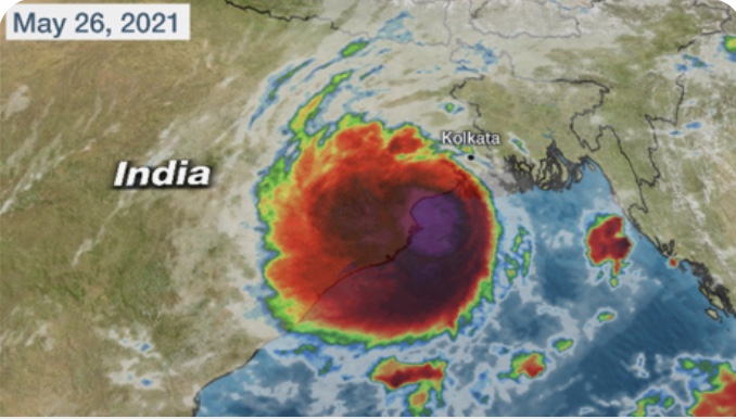
When we left basecamp over a week ago on our summit push, we were trying to thread a needle. For the past five days, the remnants of Cyclone Tauktae had pummeled the upper reaches of the mountain and made the summit inaccessible, keeping us waiting at base camp for things to clear. Meanwhile, unbelievably, a second cyclone, named Yaas, was forming in the Bay of Bengal and threatening to impact Everest as well, but it’s exact track and impact was not yet clear. So we headed up the mountain, hoping to pull off a summit attempt between the two storms.

THE ASCENT

On our first long day, we climbed the now familiar route through the icefall to Camp 1, then kept going up the Western Cym to Camp 2. The icefall had changed notably since the first time we climbed through it a month ago, with ice bridges having melted out, crevasses opened up, and sections of the route having been re-routed to accommodate collapsing ice towers and the ever moving jumble of ice.

We had planned to take a rest day at Camp 2 but, with an eye toward the ever changing weather forecast, we decided to keep moving and climbed the next day to Camp 3 at 23,500 feet. We had been there on our second rotation but this was our first time spending the night. It is in a spectacular location, carved out of a shelf half way up the Lhotse face. More than one person has slid to their death by not being super careful moving around unroped outside their tent. We were super careful.

Here is a photo taken at Camp 3 shortly after we arrived. Those are our red tents in the foreground.

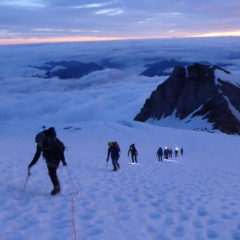
The next day, we kept on pushing and climbed up to Camp 4 at 26,000 feet. While this was another extremely demanding day, it also was exhilarating. The route starts out with some steep ice climbing up the Lhotse face above Camp 3. Then it climbs more gradually across the face, over the so – called “yellow band”, and up to and over the “Geneva Spur”.

If you are a climber or student of Everest, these geological features have an almost mythical significance. They certainly do for me. A bit like features on the moon; in another world and previously viewed only in photographs. When anticipating this climb, I promised myself that, no matter how exhausted I was, when I got to these places I would pay attention and absorb the fact that I was actually traversing them. I was indeed exhausted, but I kept my promise. I was able to look around, internalize being there, and lock in the experience for my memories.

The yellow band, by the way, is a prominent rock layer that cuts across the entire south side of Everest. It marks the beginning of the so- called “death zone”, the altitude at which the human body, if it stays there for a prolonged period of time, starts deteriorating rapidly and losing functionality. Climbers try to spend as little time in the death zone as possible.

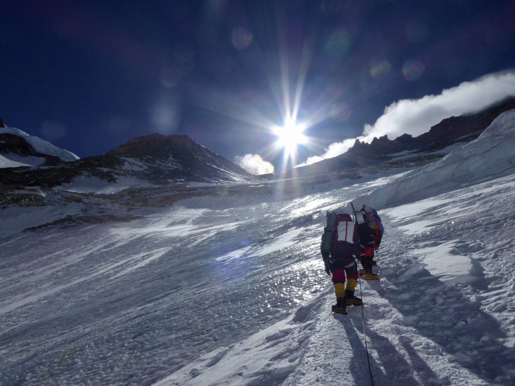
Here is a photo of Chase and Josh between Camps 3 and 4, angling up toward the yellow band and Geneva spur.

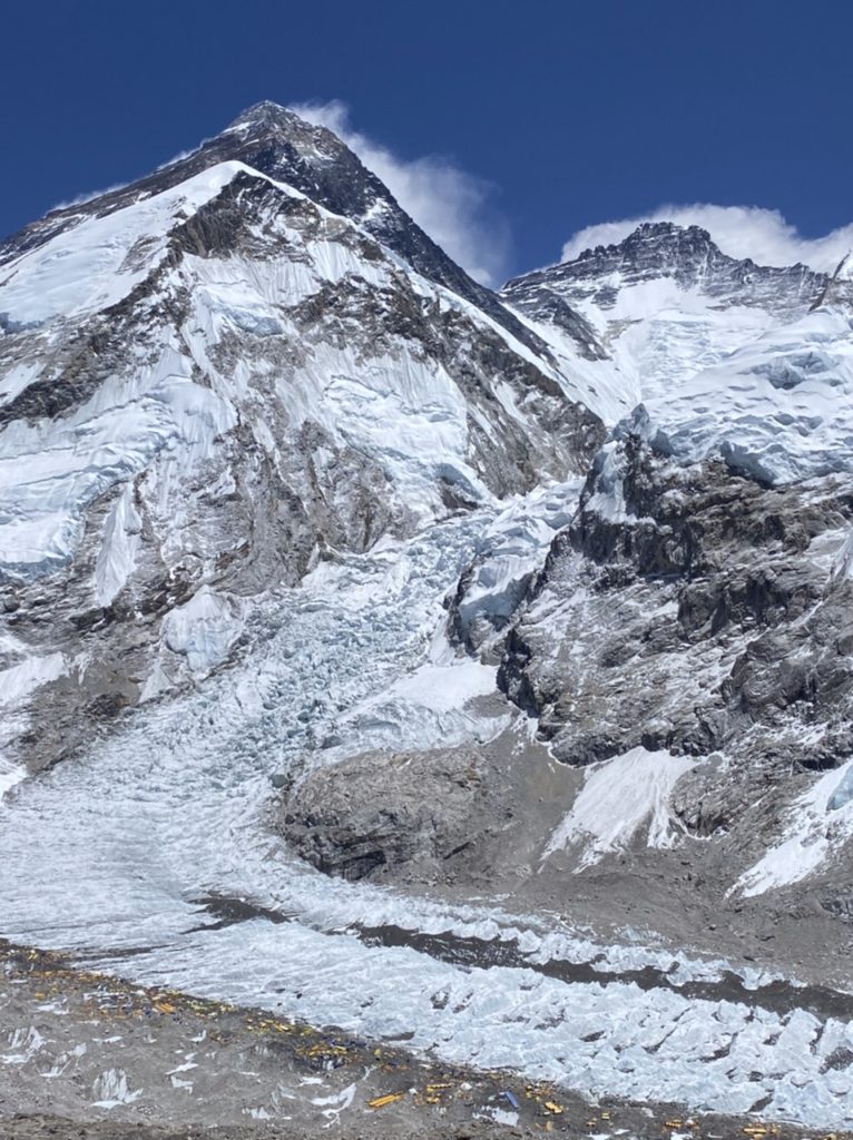
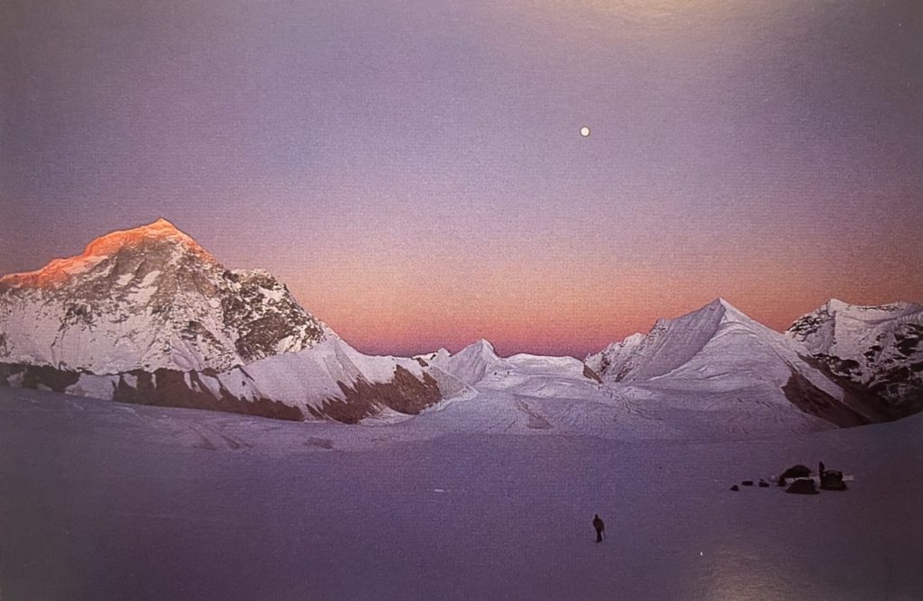
And here is another of the upper reaches of Everest, taken from the top of the Geneva spur. Our anticipated summit day route goes up the snowy “triangular face” on the bottom right, gains the right hand ridge about half way up, then follows the ridge line to the top of the world. The snow plume off the summit tells you it was windy up there.

This is a view of Everest that you don’t see a lot, unless you are thinking of climbing the southeast ridge, in which case you have studied photos of it with reverence. For me, gaining this vantage point in person was another “I can’t believe I am really here” experience.

To review the weather needle we were trying to thread: As we approached Camp 4, the remnants of cyclone Tauktae had cleared out three days previously, creating a brief window of clear weather. This created a summit opportunity for those teams that had moved up the mountain a week ahead of us and dug themselves into Camp 2 to wait out the storm. Meanwhile, the weather forecasts were united in the view that Cyclone Yaas was also heading toward Everest and would bring winds and snow to the mountain starting that afternoon. What the forecasts differed on was exactly how strong the winds and snowfall would be.

Considering these forecasts, and also factoring in how late in the season it was, many of the teams remaining on the mountain cancelled their expeditions. A few others decided to wait even longer at base camp to see if a final, extremely late weather window presented itself post Yaas. We decided to give it a shot on the front end of Yaas’s arrival.

Our weather forecaster was suggesting that, as Yaas arrived on May 25 and 26, the winds on the mountain, while significant, would be in ranges reasonable enough to permit a summit attempt. This is what we were betting on, and why we were rushing up the mountain to be at Camp 4, in position for a summit attempt on May 25 (departing the night of the 24th). This would also give us the option to defer our attempt to the 26th if needed.

All through the climb from base camp to Camp 4, I was feeling good relative to any reasonable expectation. My body was dealing with the altitude really well. I was working harder than I have ever worked on a mountain, and having to summon extreme will to put one foot in front of the other to keep moving upward, but I was feeling strong and right in the zone I wanted to be.

We pulled into Camp 4 the afternoon of May 24. Thomas and Tony, accompanied by Jangbu, had been moving more slowly than usual and arrived an hour after Josh, Chase, Ben, and me. Camp 4 , at 26,000 feet on the South Col of Everest, is often described as one of the most desolate places on earth. It lived up to its reputation. Given that we were the only team attempting this “between cyclones” weather window, there were only two other climbers up there, which made it feel even more remote. As we threw ourselves into our tents, the clouds and wind arrived exactly as forecast. The winds increased as the afternoon progressed, and that evening Ben decided to postpone our summit attempt to the 26th.

We spent the night of the 25th and all day on the 26th in our tents: breathing bottled oxygen, listening to the wind howl, and feeling the wind violently shake our tent walls. Mid afternoon, one of our climbing Sherpas, Pema, unzipped our tent door to fill our water bottles and give us fresh bottles of oxygen. It was amazing that he could be out in those conditions. “Pema, how is it going?”, I asked. “I’m worried. The winds aren’t dropping“, he answered. I rolled back into my sleeping bag and hoped for the best.

A couple of hours later, the tent walls began shaking a bit less violently and the howls of the wind were a bit milder. We were beginning to get the drop in winds we were hoping for. Early that evening, Ben came by each tent and announced that we would go for the summit that night. The winds would be strong but, assuming we were flawless in our protection against frostbite, we should have a good chance at the summit. It would be cloudy and perhaps snowing lightly, but that shouldn’t stop us.

Because we were basically alone up there, we didn’t have to worry about crowds slowing us down, and we had the flexibility to leave whenever we wanted. Ben said we would depart sometime between 2:00am and 6:00am. He would monitor the conditions and wake us up two hours before departure.

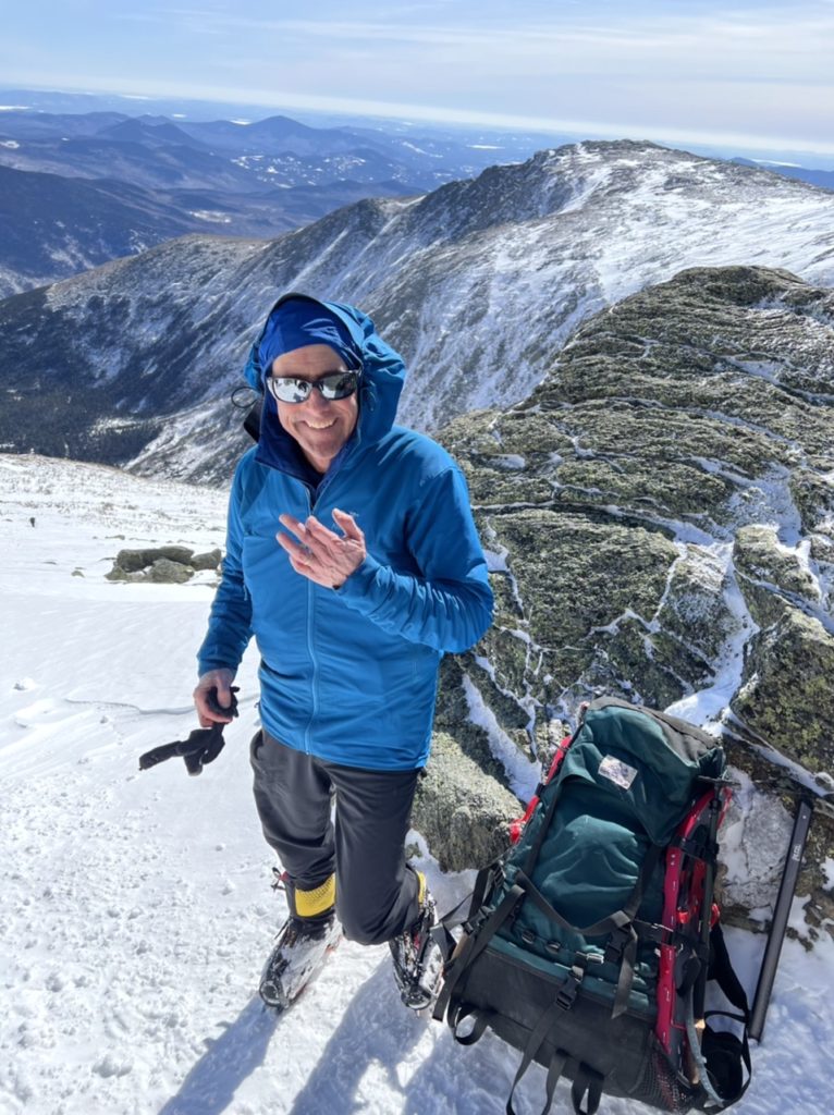
We were going to get our shot! I was elated. After so many years, I was in the position I had long dreamed of and tried to picture: in a tent on the South Col of Everest, hours from leaving for the summit. I was feeling good, was in a strong team, and in the company of the best guides and climbing Sherpas possible. And, amazingly, we would have the summit ridges to ourselves. I had no doubt I would get to the summit. Almost too good to be true. Here is a photo of me that evening about to climb into my sleeping bag, hours before “go time”:

I lay in my bag, alone with my thoughts, drifting in and out of light sleep. Around midnight, I realized that Ben hadn’t woken us up yet . The winds felt strong, but not overly so. I unzipped the tent door and noticed that snow had accumulated in our vestibule. Around 1:00am, I again realized that Ben hadn’t woken us up, and assumed that he had decided on the later 4:00am departure time. That meant we would be woken up in one hour, at 2:00am. I drifted back to sleep.

The next time I woke up, something felt weird. My internal clock sensed that a bunch of time had passed. I looked at my watch. It read 4:30 am. I unzipped our tent door and saw that our vestibule was filled with a massive snow drift. Outside the vestibule, it was snowing heavily. I shook my tent-mate Thomas awake, took off my oxygen mask so he could hear me, and said: “We’re not going!”

During the night, Ben and Jangbu had gotten out of their tent every hour to check on the conditions. The winds were in the zone we expected. The steadily increasing snowfall was not. Furthermore, it was dense, heavy snow that reduced visibility to almost zero and would make climbing exceedingly difficult. They realized they had no choice but to abort.

As day broke and it continued to snow heavily, Ben and Jangbu considered all options. They spoke with Lakpa Rita at base camp by radio and considered whether Sherpas could carry up more oxygen to allow us to wait at Camp 4 more days, for a possible last weather window after Yaas cleared out. However, the Sherpas were exhausted from weeks of carrying loads with reduced numbers, (due to accidents and illness). Even if they could get us more oxygen, a prolonged stay in the death zone would be dangerous. And what if the storm lasted more days than forecast, as Tauktae had just done, and they were unable to reach us with the extra oxygen? In that case, we would all join the ranks of statistics we had vowed not to join.

The answer was clear. We had no choice but to descend. And we had to do it immediately, in a snowstorm, before conditions got any worse. We began the multi hour process of getting ready. In a stroke of good fortune, the snowfall paused for a couple of hours, making our preparations easier. Here is a photo of us getting ready to leave Camp 4:

THE DESCENT

The descent turned out to be what you should expect, and then some, if you descend from 26,000 feet on Everest in the middle of a snowstorm.

Our initial goal was to get down to Camp 2, which meant descending the entire Lhotse face. As we left Camp 4, the snow and winds both picked up again, making walking difficult, even over the relatively level ground to the top of the Geneva Spur. We stopped at the top of the spur to wait for Thomas, who – accompanied by Jangbu- was moving more slowly than us. We waited, and waited, and waited.

What was going on? It usually takes less than 30 minutes to get from Camp 4 to where we were standing, and Thomas had started out with us. The wind and snow were whipping, and it was hard to stay warm when not moving. Finally, they appeared. Thomas was having difficulty picking his way over the rocky terrain in the snow. It was hard to believe how slowly he was moving. After more excruciating minutes, they joined us at the top of the spur.

From that spot, it is a short rappel, followed by some steep down climbing, to the bottom of the spur. I was kind of dreading it, as this would be the first tricky descending we would have to do in these conditions. Simple things, like clipping in and out of the fixed lines to move around anchor points, and braking yourself by wrapping the ice covered rope around your arms, would be far more difficult.

Ben led off. Josh, Chase, Tony, and I followed him over the top of the spur and down into the driving snow. Within 30 minutes, we were all safely at the bottom of the spur, where we stopped again to wait for Thomas and Jangbu, When we looked back up to check on their progress, we couldn’t believe what we saw.

Thomas and Jangbu were still near the top of the spur, with Thomas having extreme difficulty descending. When rappelling, his feet kept slipping out from under him, and he was having trouble moving around the anchor points. Jangbu was close behind him, assisting him with every step. We watched with concern, and also struggled personally to stay warm as we sat in the snowstorm, not moving.

Thomas reached less steep terrain and walked toward us. What shocked and horrified me was that he was still having trouble making forward progress. His knees kept buckling under him. This was the same strong climber and athlete who had been doing great the entire expedition. Meanwhile, we had been sitting in the snow at the bottom of the spur for over half an hour and were getting cold.

It was at this point that I had the realization: this is the way things can suddenly go very bad. There is a thin line between challenging climbing and a desperate situation, and we were close to it. We were at 25,500 feet, in the middle of a snowstorm, and the only people up there. There was no way we could get Thomas down unless he kept walking under his own power. He needed to keep walking. He knew it, Jangbu knew it, we all knew it.

Jangbu, as always, maintained total calm and an aura of quiet confidence, but he later told Thomas: “I was really worried for you. And I was worried for me. I would never leave you.”

In one of those seminal moments of our descent, Thomas dug deep and found the ability to get his legs moving again. Jangbu followed right behind him, supporting him with a short rope. We all proceeded down the Lhotse face, with Thomas and Jangbu falling increasingly far behind in the swirling snow, but definitely moving downward.

I turned my attention back to myself. I had to stay focused and not make any mistakes. Any time I came to an anchor point, I knew that if I failed to clip back into the fixed line properly and lost my footing, I would fall all the way down the face. Doing things properly was much more difficult in the driving snow and wind. Little things became extremely important, like making sure my goggles didn’t fog. Anyone who has hiked or skied in a blizzard can picture what I am talking about.

From our previous ascents between camps, I knew the sections I was most worried about: the steep drops and ice bulges where I would have to rappel extremely carefully. The first of those awaiting me was the yellow band. When I got there, Ben, Josh, and Chase had just finished descending it and were lost from sight in the snow. Tony was somewhere above and behind me, and Thomas and Jangbu even more so. It was one of those moments where you are all alone in a challenging situation, with no one watching or helping, and know you just have to execute. I concentrated intensely on clipping in and out of the maze of ropes dangling over the rock face, panting heavily from the physical effort. I reached the bottom of the yellow band and continued downward.

The next section that concerned me was the steep ice bulge just above Camp 3. Ben, Josh, and Chase were waiting for me there. We followed each other in rappelling down it and arrived at the cluster of tents. We were more than half way down to Camp 2!

We took what we initially intended to be a short break at Camp 3. Then Ben’s radio crackled. It was Jangbu, saying he needed some additional help and asking us to wait for him before descending further. One of our climbing Sherpas, Raj, had stopped using his glacier goggles and developed snow blindness. He couldn’t see more than a foot in front of him. In addition to helping Thomas, Jangbu was helping Raj, and it was more than he could handle on his own. So our planned brief stop at Camp 3 turned into an hour long wait.

The biggest challenge was staying warm. The winds had increased in strength and the gusts were blowing the snow sideways. After around 20 minutes, I could feel my core temperature declining and I was starting to shiver. So I dove into a nearby tent from another expedition, with my feet extending outside the door so my crampons didn’t rip the tent. It was mostly full of oxygen bottles and other expedition gear, but there was room for one person. It is amazing what a difference thin tent walls can make. Inside the tent, I was warm, and could relax while waiting for the others to arrive. Here is a photo I snapped of my view back out the tent door, with Chase and Ben staunchly continuing to wait outside:

Finally, the others arrived. I was amazed they had managed to descend the final ice wall without incident, and – credit to all three of them – they had. I got out of the tent so Thomas could get in to warm up and rest. I began to worry that he wouldn’t summon the will to emerge from the tent, but – in a second seminal moment of the descent- he did.

Then we all continued our descent toward Camp 2. Josh and Chase in the lead, then me and Tony, then Ben helping Raj with a short rope, then Jangbu doing the same with Thomas. The final challenge came at the bergschrund at the bottom of the Lhotse face, which required a lateral traverse across a narrow ice ledge, with a deep crevasse looming below. The driving snow had made the ledge even narrower than usual, and it was harder to get good purchase on it with your crampons. Also, the ice wall pushed you out away from it every time you took a step.

Josh, then Chase, then me, then Tony, all cautiously inched across it, breathing big sighs of relief when we got to the other side. Then we climbed down to where the slope eased off, and collectively looked up the face for signs of Ben, Raj, Jangbu and Thomas. They appeared first as pairs of small dots far up the face. We watched them climb down through the still driving snow to the bergschrund.

As we watched anxiously from below, both pairs slowly and carefully navigated the bergschrund, with Ben and Jangbu expertly setting up additional belay lines and providing directional guidance. Raj and Thomas inched along the ledge in turn without losing their footing. After they both got across, we knew we were in good shape. It was 45 minutes of straightforward downhill walking to Camp 2. We were safely down!

Except of course we weren’t fully down. We still had to descend the Western Cym, then down through the icefall one final time. The snow continued all night, and it was still snowing when we departed Camp 2 at 6:00 am the following morning. Instead of the usual easy downhill walk to Camp 1, we had to break trail through more than a foot of new snow. Even finding the trail was difficult; made more difficult by full whiteout conditions. With crevasses all around, and mindful that a Sherpa had fallen into one of them and died just a week ago, we had to pick our way very carefully. Ben and Jangbu did a masterful job of doing just that.

We took a break at Camp 1, then headed into the icefall, where the ice bridges were even more melted out than they had been on our ascent, the required rapells into some of the ice ravines longer, and the leaps across open crevasses more demanding. All of this was complicated by the continued snowfall, which obscured hazards and made it harder to get confident purchase with your crampons. The lower we got, the wetter the snow got. Despite having “anti- balling plates” on our crampons, the wet snow balled up under them anyway, creating inches of snow buildup that made us stumble and further eroded our ability to kick the crampon points into the ice.

Finally, we emerged out of the icefall; our sixth of six passages through it now completed. At this moment, I let myself begin to relax and thanked whoever was listening for granting us safe passage. From there, it was an easy 30 minute walk to base camp.

THE AFTERMATH

Yaas continued to pound Everest. It snowed steadily, at all levels of the mountain, for two more days. Base camp received over two feet of snow. We stayed holed up, unable to make desired connections with family and friends as the internet service was knocked out.

Several expeditions eying a post Yaas weather window have been pinned down at Camp 2. No one has been able to move up the mountain, and – increasingly- the teams at Camp 2 are uncomfortable moving down the mountain, due to avalanche risk from all the new snow. No one has summited since May 23, and it is unclear if there will be any more summits this season. This morning, we heard reports that a large avalanche down the Lhotse Face wiped out all of Camp 3, but I have yet to fully confirm this. Our guess and hope is that no one was in Camp 3 at the time due to the poor weather conditions.

This morning, the snow finally stopped. The clouds lifted, and we were able to helicopter to Kathmandu. After posting this through the hotel internet, I am about to have my first shower in a long while. Then I am going to start figuring out how to get home given that Kathmandu is in full Covid lockdown and the flights have been largely shut down. There has been some easing of this recently and I think things will work out somehow.

The past few days in base camp provided helpful time for reflection on our climb; on what we did and didn’t achieve. As I said would be the case before departing on our summit push, I really am at peace with the fact that we didn’t summit, and really do feel like I got 90 percent of the Everest experience I dreamed of. That said, the final 10 percent really hurts. We were so close, and so ready to climb the final 7-8 hours it would have taken us to reach the top of the world. Only now do I realize how much, deep inside, I was expecting to be standing up there.

I am proud of our team. We pushed right to the edge of prudent risk to set ourselves up with a shot at the summit; the only team to get up to the South Col between cyclones. When the risk became too much, we made the right decision and backed off. We then descended safely in very challenging conditions. We lived up to the quote by mountaineer Ed Viesturs that I have shared previously: “getting to the top is optional, getting down is mandatory”.

I am down, and really looking forward to coming home.

I think one final blog post, (much shorter than this one!), may make sense in the coming days. I can update you on how the final climbing days on the mountain played out, on some good team reflections after getting back to base camp, on our exodus today from base camp to Kathmandu, and a few other things.

Meanwhile, thanks for slogging through this.  Happy Memorial Day Weekend to all!

Starting our summit push

We are leaving tomorrow night on our summit push.
It has been over a week since we returned to base camp from our second rotation, and – as described in my last post- we have been waiting for an ideal weather window. Unfortunately, recent weather trends have complicated the summit window picture, but we will give it our best shot.

The original May 19-21 window that a number of teams had been targeting, (and that we were consciously sitting out), has gotten compressed and pushed a couple of days later by remnants of a cyclone that moved up from the Bay of Bengal. All the teams that headed up the mountain this past weekend in anticipation of that first window have been dug in at Camp 2 for the past five days riding out the bad weather. It looks like a brief, and somewhat windy, window will open around May 22, and we expect a number of the teams already up there to go for the summit then.

Meanwhile, the weather forecast for the last week of May, the period that we have been eying for our summit attempt, remains unclear. It looks like a second window may emerge around May 25-27. If it does, that will likely be our best shot. If it doesn’t, we may be out of luck. The situation is complicated by the fact that, if you can believe it, a second cyclone is now forming in the Bay of Bengal. Our weather forecaster believes this cyclone will track toward Bangladesh and not impact Everest, but some other forecasters aren’t so sure.

This may end up being another one of those years when the mountain offers up relatively few total summit days. It could end up being as few as three or four, with two having already happened earlier this month. Or, if the May 25-27 window comes through, it may end up being as many as six or seven.

Our main goal now is simply to get a shot at the summit before the season shuts down. We will head to Camp 2, establish ourselves there, and hope that we get a decent window for a summit attempt somewhere in the May 25-30 timeframe.

As a reminder, here is a map of our route and the various camps that appeared in an earlier post, courtesy of Alan Arnette and his website alanarnette.com:

We will leave basecamp at midnight and climb through the Icefall, past Camp 1, and up the Western Cym to Camp 2. This will likely take us 10-12 hours. At Camp 2, we will spend at least one full rest day, and potentially more depending on the weather outlook. We will then move to Camp 3 and spend the night, and the next day move up to Camp 4 at the South Col. At Camp 4 we will spend somewhere between six to thirty hours resting, (again, depending on the weather outlook). Assuming all systems are go, we will then head for the summit.

Of note, starting at Camp 3, we will be climbing and sleeping on bottled oxygen.

Assuming the weather allows us to launch a summit bid, we will likely leave Camp 4 sometime between 9:00pm -midnight and climb through the night, hoping to arrive at the summit early in the morning. We will then descend back to Camp 4, and spend the night there. The next day, we will descend to Camp 2, and then the following day descend back to basecamp.

Lots of moving parts depending on how the weather evolves, but that is the general plan. I think it is greater than 50 percent likely we end up getting some kind of shot at the summit, although it may not be in the ideal weather or crowd conditions we had been hoping for. Rest assured: we will only go for the summit if we feel the conditions on both dimensions are safe, (as safe as they can be up there).

For those of you who have been doing the math, this all suggests that we will return to basecamp, one way or the other, sometime between May 27-June 1.

SOME COMMUNICATION LOGISTICS

I will of course post an update when we return to basecamp.

Meanwhile, I will be carrying a small satellite tracking device that allows me to send short messages to my family. If and when we lock in on a summit attempt, Jill has graciously offered to email this readership list with an update on that timing.

If we do end up going for the summit, I will carry my satellite tracking device. For those of you who are up for it, (I don’t expect there to be many, but I know there are a few), you can track my progress real time on summit night/day at: https://share.garmin.com/SUO62

If you try to track me and the signal isn’t working, don’t worry. Batteries can easily freeze up there.

Also, for anyone interested in additional information while we are above base camp, our Expedition Leader, Ben Jones, will be posting brief updates via satellite, roughly daily, at: https://www.alpineascents.com/climbs/mount-everest/cybercasts/

On summit night/day, Ben will also radio periodic updates to Lakpa Rita down at basecamp , who will post them on this same link.

ADDITIONAL THOUGHTS

Despite the somewhat challenging weather outlook, the team and I remain in high spirits. Being at the mercy of Mother Nature and the weather gods is a core component of mountaineering. Whether or not we ultimately get to the summit, we feel great about how we have approached climbing this mountain.

While I intensely hope things break our way and we get to stand on the top of the world, I will be at peace if this ends up not happening. My lifelong dream of climbing Everest has on many dimensions already been fulfilled, and will be fulfilled even more as we head up the mountain on our final rotation.

As described in an earlier post, I currently have around my neck: 1) the protection cord blessed by the monks of Sharminub monastery in Kathmandu, 2) the protection cord blessed by the lama of Pangboche, 3) the protection cord given to us by the mother and son at the tea house in Namche, and 4) my wedding ring.

Yesterday, Lakpa Rita walked into our dining tent and tied an additional protection cord around each of our necks. In his typical, understated manner, he didn’t go into a lot of detail on where they came from, but Ben later explained. Apparently, Lakpa’s wife organized, (and paid for), another puja ceremony for our expedition down in Namche. She was mindful that this has been a particularly challenging season, including the accident our Sherpas were involved in at the bottom of the Lhotse face, the portion of the icefall collapsing on Bob and Ang Nuru, and the ongoing complications of dealing with Covid. The protection cords were then carried up the valley to basecamp by a porter. So now I have an additional cord around my neck.

When we leave basecamp tomorrow night to head into the icefall, we will – as always when we are heading up the mountain- make a counter clockwise circuit around the puja alter in our camp that the Sherpas constructed, and throw handfuls of rice on it. Also, as always when anyone on our expedition heads up the mountain, our Sherpas will be burning juniper in the alter.

So we are blessed.

Off we go. Ever Upward!

p.s. I have promised Jill I will shave before I get home.